How it works

One project from the pin to the report, then the charts, then one number followed from the workspace to the reviewer’s page. Every image is the running product; every number in a caption is the engine’s.
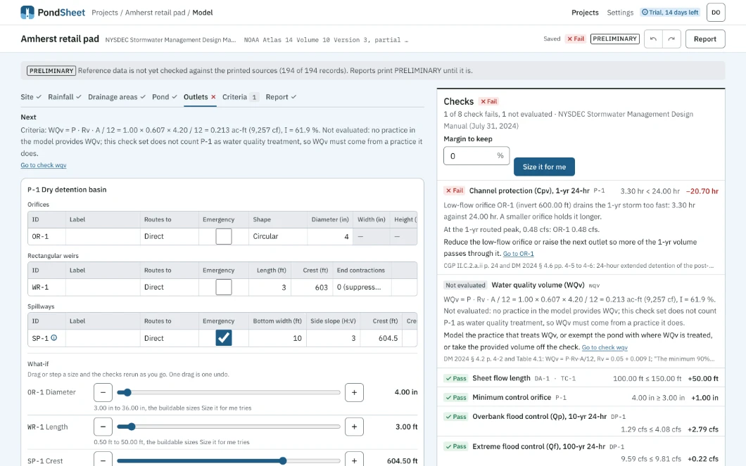
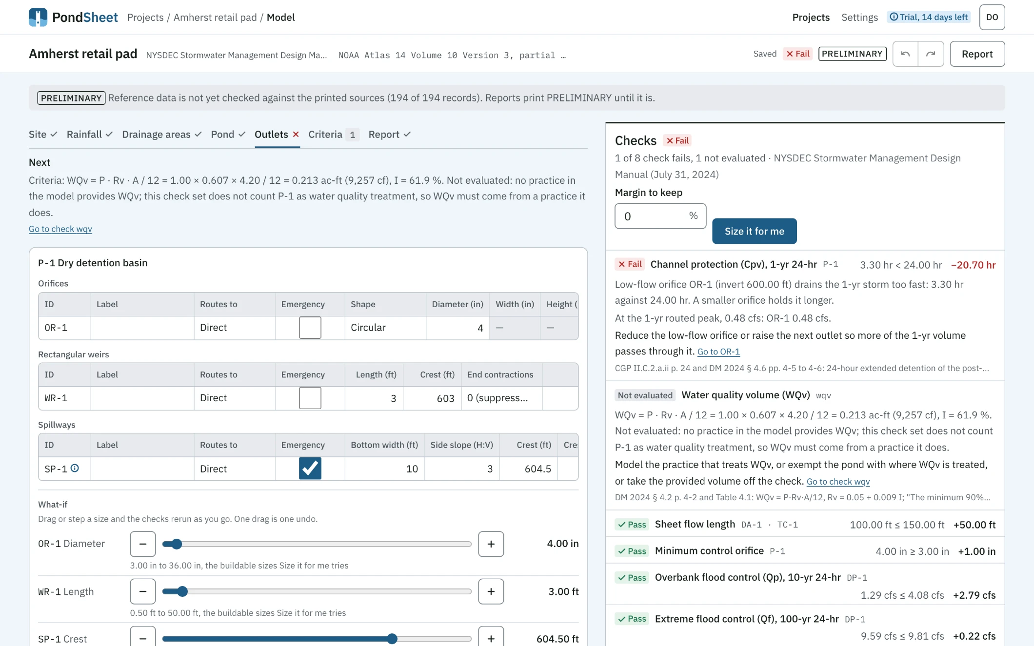
The PondSheet workspace for the Amherst retail pad on the Outlets tab. A strip names the project, the NYSDEC 2024 check set and the NOAA Atlas 14 rainfall, with Saved, a Fail verdict, PRELIMINARY, undo, redo and Report; under it the PRELIMINARY notice and a step rail with Outlets marked. A Next line names the WQv check that is not evaluated. Left, pond P-1's outlets: orifice OR-1 4 in, weir WR-1 3 ft long with its crest at 603, emergency spillway SP-1 crest 604.5, then a what-if slider for each. Right, the checks, under a margin-to-keep field and a Size it for me button: Cpv fails at 3.30 hr against 24.00 hr with a hint naming OR-1.
The workspace on the Amherst retail pad: the outlets on the left, every check against the NYSDEC 2024 template on the right, re-run on each edit. Cpv fails at 3.30 hr against 24.00 hr, and the hint names the orifice. Open at full size

In: a pin on the site. Out: the NOAA Atlas 14 depths for that point and the USDA soil survey over the parcel, each frozen with the project and printed in the report with its source.
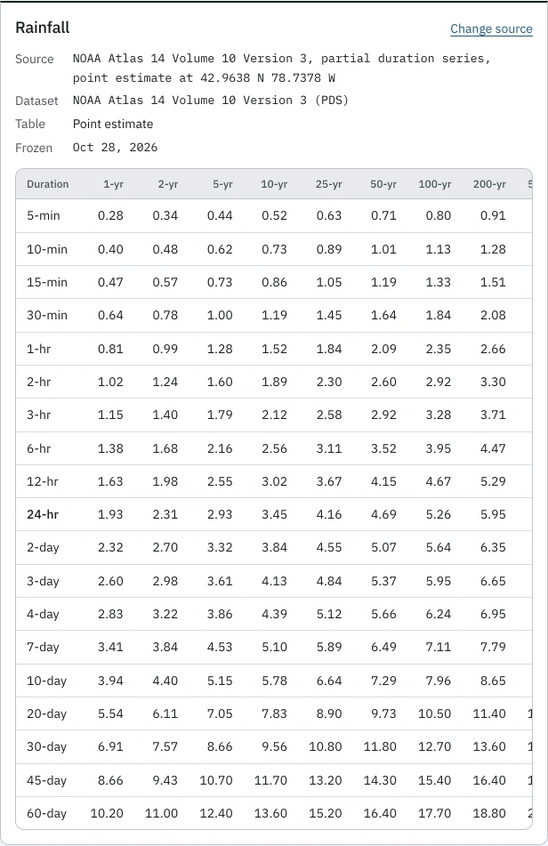
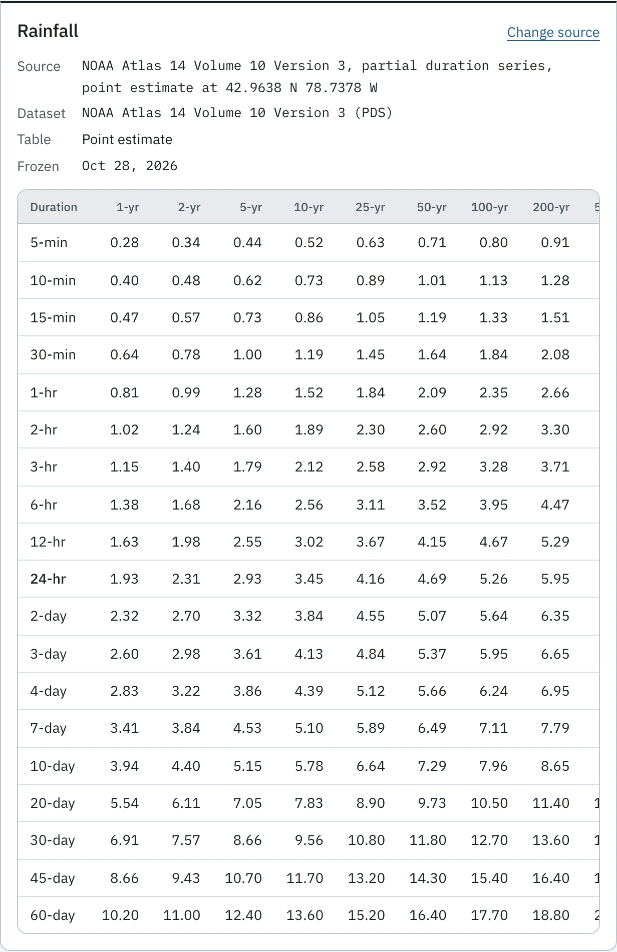
The Rainfall panel of the Amherst retail pad. Source: NOAA Atlas 14 Volume 10 Version 3, partial duration series, point estimate at 42.9638 N 78.7378 W; dataset NOAA Atlas 14 Volume 10 Version 3 (PDS); frozen Oct 28, 2026. Below, the depth table from 5-min to 60-day across the return periods, the 24-hr row in bold: 1.93 in at 1-yr, 3.45 in at 10-yr, 5.26 in at 100-yr.
Site and rainfall, Amherst retail pad: the Atlas 14 depths for the pin, frozen with the project on Oct 28, 2026, with the dataset and version. They change only when the engineer updates them. Open at full size
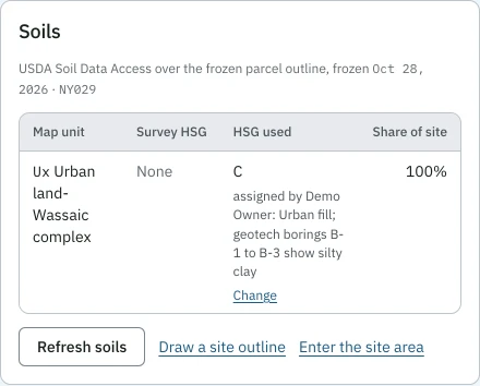
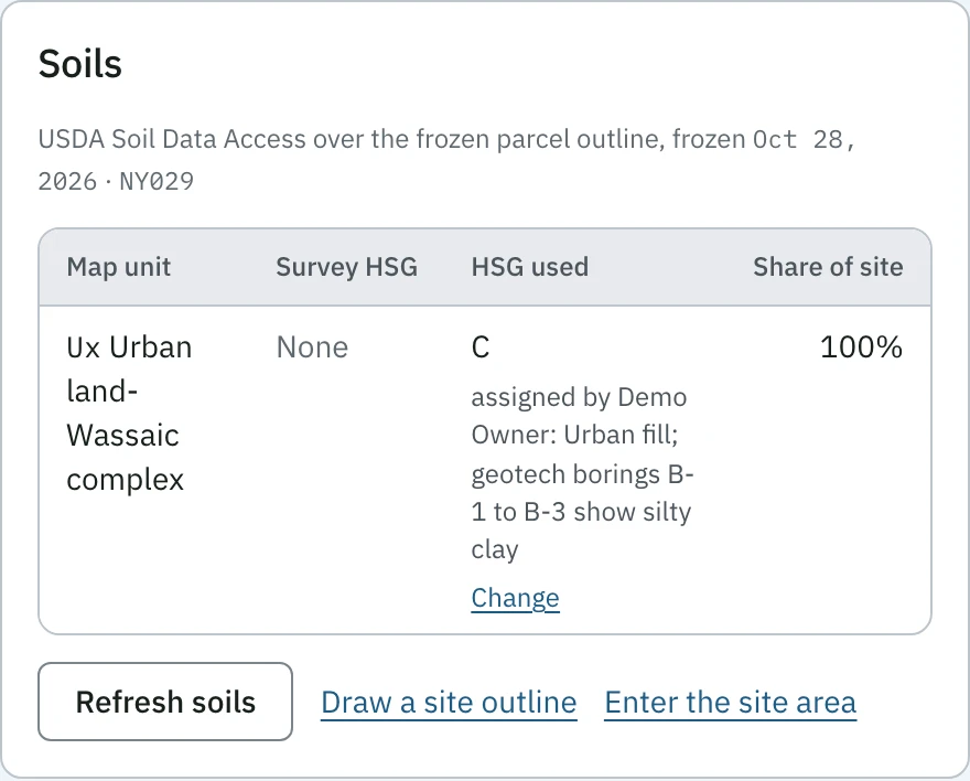
The Soils panel of the Amherst retail pad: USDA Soil Data Access over the frozen parcel outline, frozen Oct 28, 2026, survey area NY029. One map unit, Ux Urban land-Wassaic complex, survey HSG None, HSG used C, assigned by the engineer with the reason: urban fill, geotech borings B-1 to B-3 show silty clay.
Soils, Amherst retail pad: the survey gives urban land no group, so the engineer assigned C with the borings as the reason, and the change is logged. Open at full size

Drainage areas: CN and Tc

In: cover, soil group and area for each subarea, and the flow path. Out: the composite CN and Tc by TR-55, before and after development.
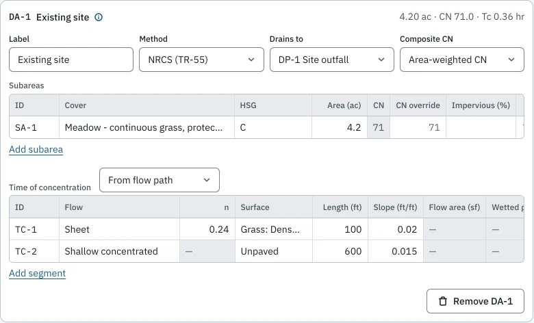
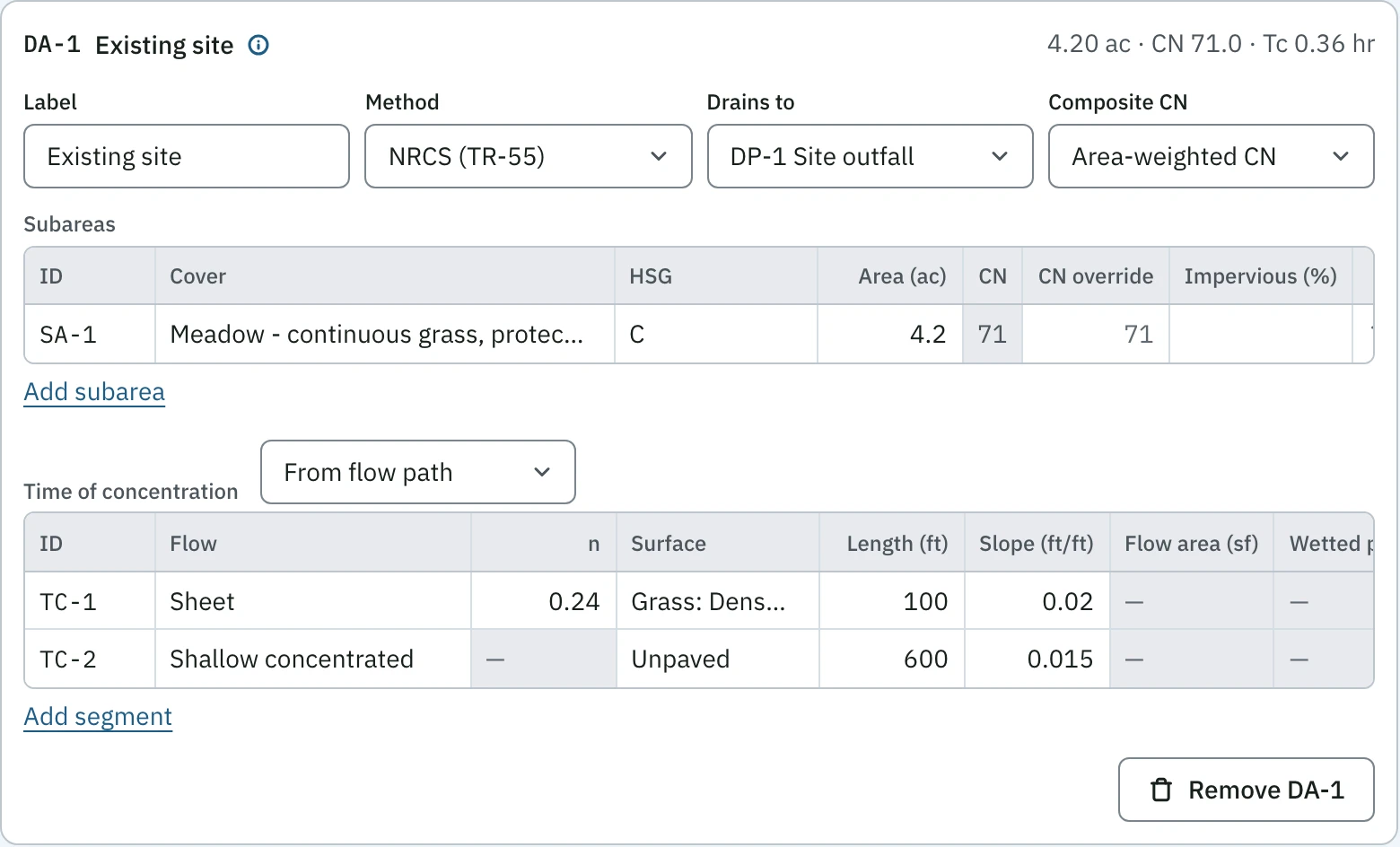
Drainage area DA-1, Existing site, on the Amherst retail pad: 4.20 ac, CN 71.0, Tc 0.36 hr, NRCS TR-55 method, draining to DP-1 Site outfall. One subarea, meadow on HSG C, 4.2 ac, CN 71. Tc from the flow path: TC-1 sheet flow, n 0.24, 100 ft at 0.02 ft/ft, and TC-2 shallow concentrated, unpaved, 600 ft at 0.015 ft/ft.
Drainage areas, Amherst retail pad: cover, soil group and area give CN 71.0; a 100 ft sheet flow and 600 ft of shallow flow give Tc 0.36 hr, by TR-55. Open at full size

The pond: stage-storage

In: the stage-area table, typed or pasted. Out: storage at each stage and the discharge through the outlets there.
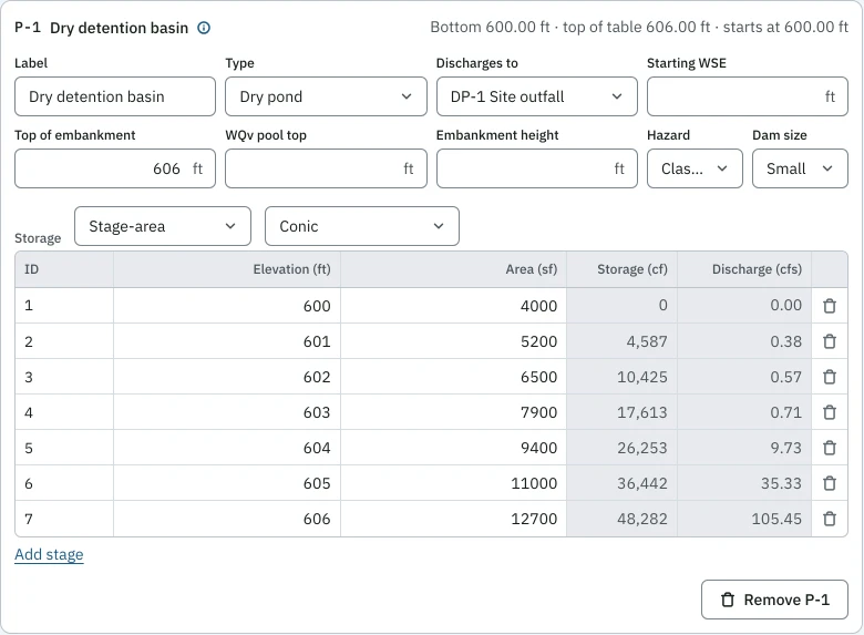
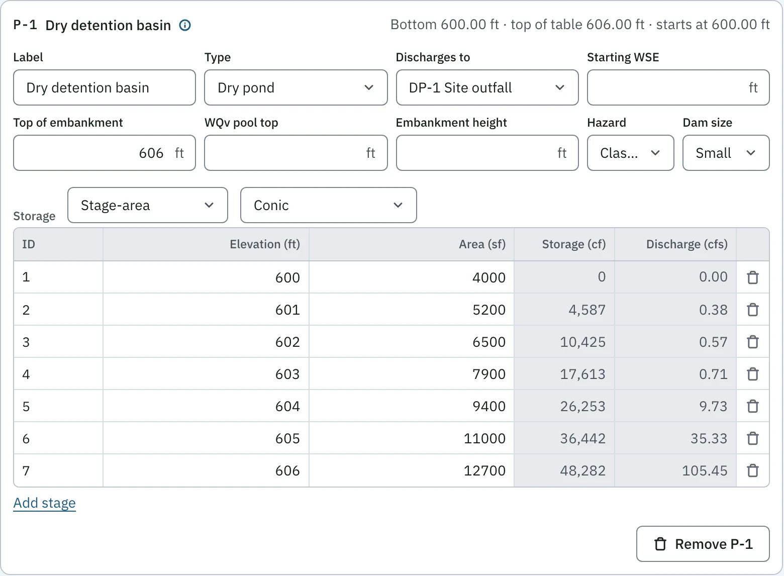
Pond P-1, Dry detention basin, on the Amherst retail pad: bottom 600.00 ft, top of table 606.00 ft, top of embankment 606 ft, draining to DP-1. The stage-area sheet by the conic method, seven stages from 600 ft at 4,000 sf to 606 ft at 12,700 sf, with the computed storage and discharge beside each: 48,282 cf and 105.45 cfs at 606 ft.
Pond, Amherst retail pad: the stage-area table, typed or pasted from Excel or a Civil 3D report, gives storage by the conic method and the discharge through the outlets at each stage. Open at full size

Outlets

In: orifices, weirs, a riser, the emergency spillway, a barrel. Out: the routed outflow for every storm, re-run on each edit, and a slider on each outlet’s size.
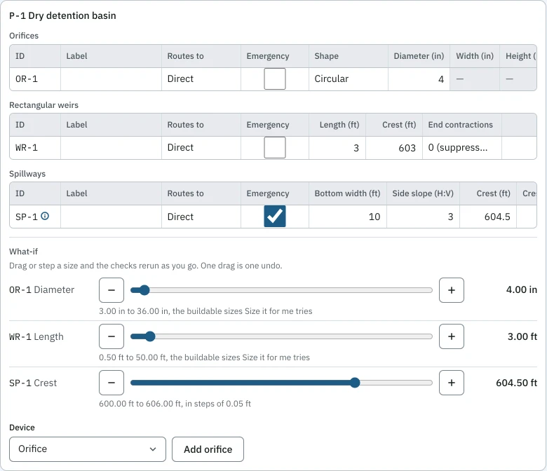
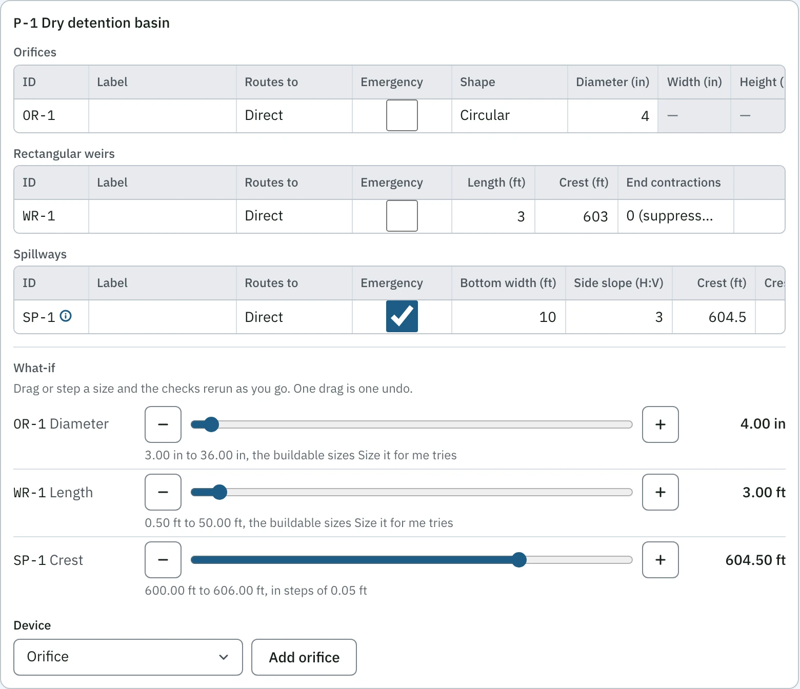
The outlets of pond P-1 on the Amherst retail pad: orifice OR-1, circular, 4 in; rectangular weir WR-1, 3 ft long, crest 603, no end contractions; emergency spillway SP-1, 10 ft bottom width, 3:1 side slopes, crest 604.5. Under them, What-if sliders for OR-1 diameter 4.00 in, WR-1 length 3.00 ft and SP-1 crest 604.50 ft, each on the sizer's standard sizes.
Outlets, Amherst retail pad: an orifice, a weir and the emergency spillway, each with a slider on buildable sizes; the checks re-run as you drag, and one drag is one undo step. Open at full size

Checks against the criteria you select

In: your check set, or a template (here the NYSDEC 2024 manual), each check with the source you cite. Out: pass or fail on each, the comparison and margin, and on a failure the outlet to change.
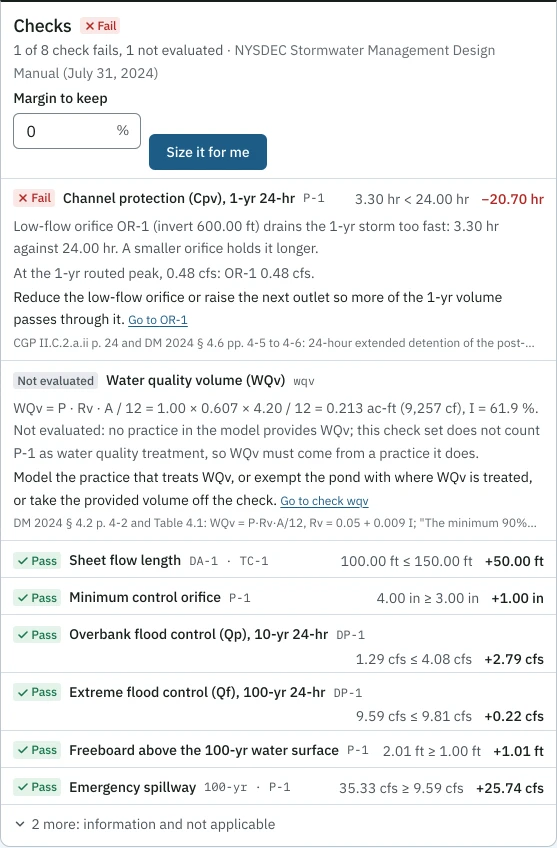
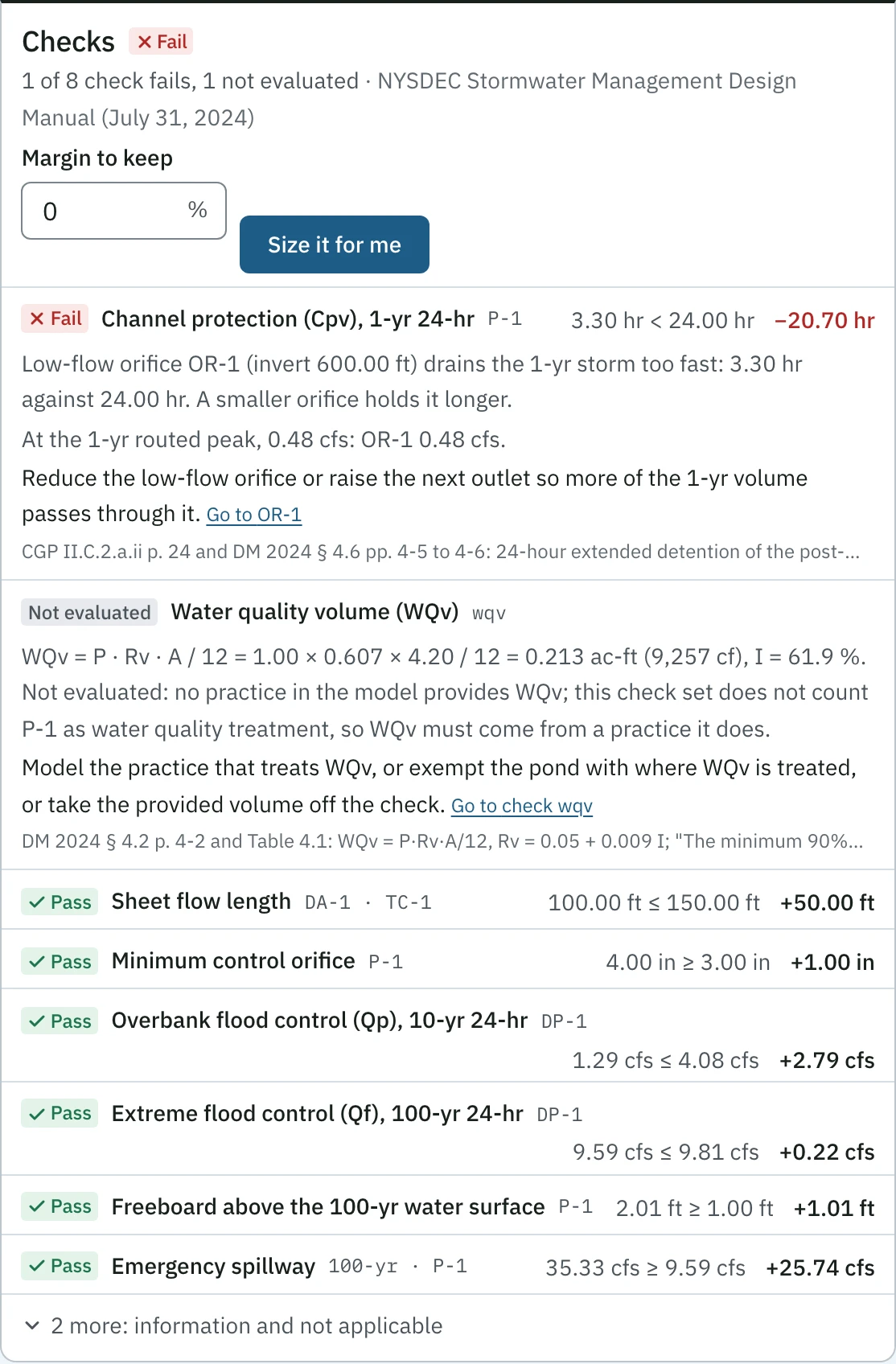
The checks panel for the Amherst retail pad against the NYSDEC 2024 manual: Fail, 1 of 8 checks fails and 1 is not evaluated, over a margin-to-keep field and Size it for me. Cpv fails at 3.30 hr against 24.00 hr, short by 20.70 hr, with the hint that low-flow orifice OR-1 drains the 1-yr storm too fast. WQv is not evaluated: a dry pond does not count as WQv treatment, and the hint names the three ways to resolve it. Sheet flow length, minimum orifice, Qp 1.29 cfs against 4.08 cfs, Qf 9.59 cfs against 9.81 cfs, freeboard 2.01 ft and the emergency spillway pass, each with its margin.
Checks against the criteria you select, Amherst retail pad: each with its comparison, its margin and the manual section cited, and a failure says which outlet to change. Open at full size

Size it for me

In: a failing check. Out: the smallest change to buildable outlet sizes that passes, every number from a run of the proposed model; the engineer applies it or not, and undo puts it back.
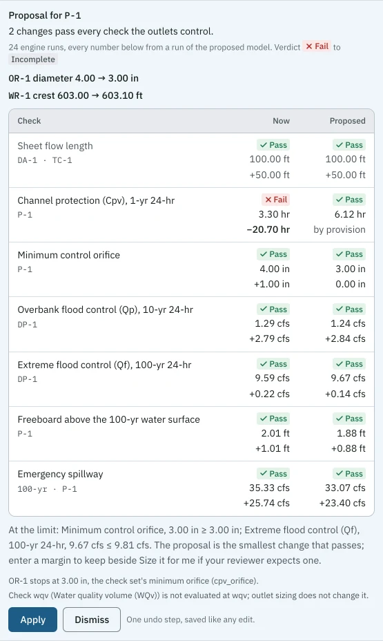
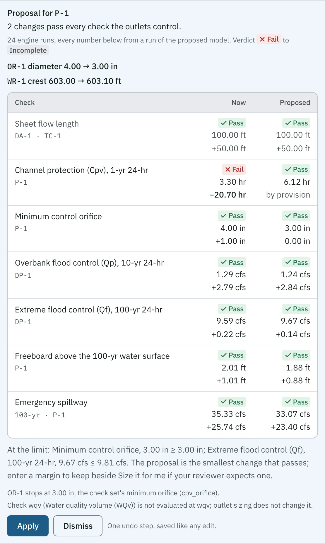
Size it for me's proposal for pond P-1 on the Amherst retail pad: two changes pass every check the outlets control, from 24 engine runs, the verdict going from Fail to Incomplete: OR-1 diameter 4.00 to 3.00 in and WR-1 crest 603.00 to 603.10 ft. A table of now against proposed: Cpv from Fail at 3.30 hr to Pass at 6.12 hr by provision; minimum orifice 3.00 in; Qp 1.24 cfs; Qf 9.67 cfs; freeboard 1.88 ft; emergency spillway 33.07 cfs. A line names the two checks left at their limit. Apply and Dismiss below.
Size it for me on the Amherst retail pad: OR-1 4.00 to 3.00 in and WR-1 crest 603.00 to 603.10 ft, every number from a run of the proposed model. Apply is one undo step. Open at full size
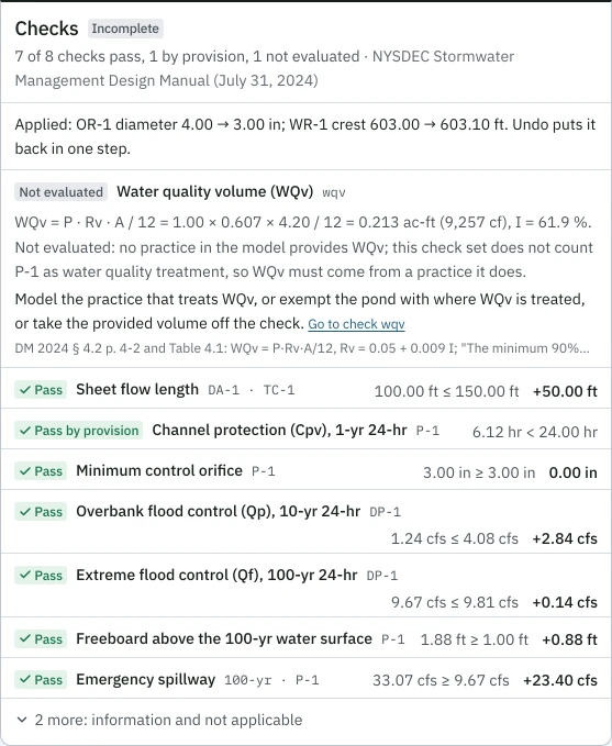
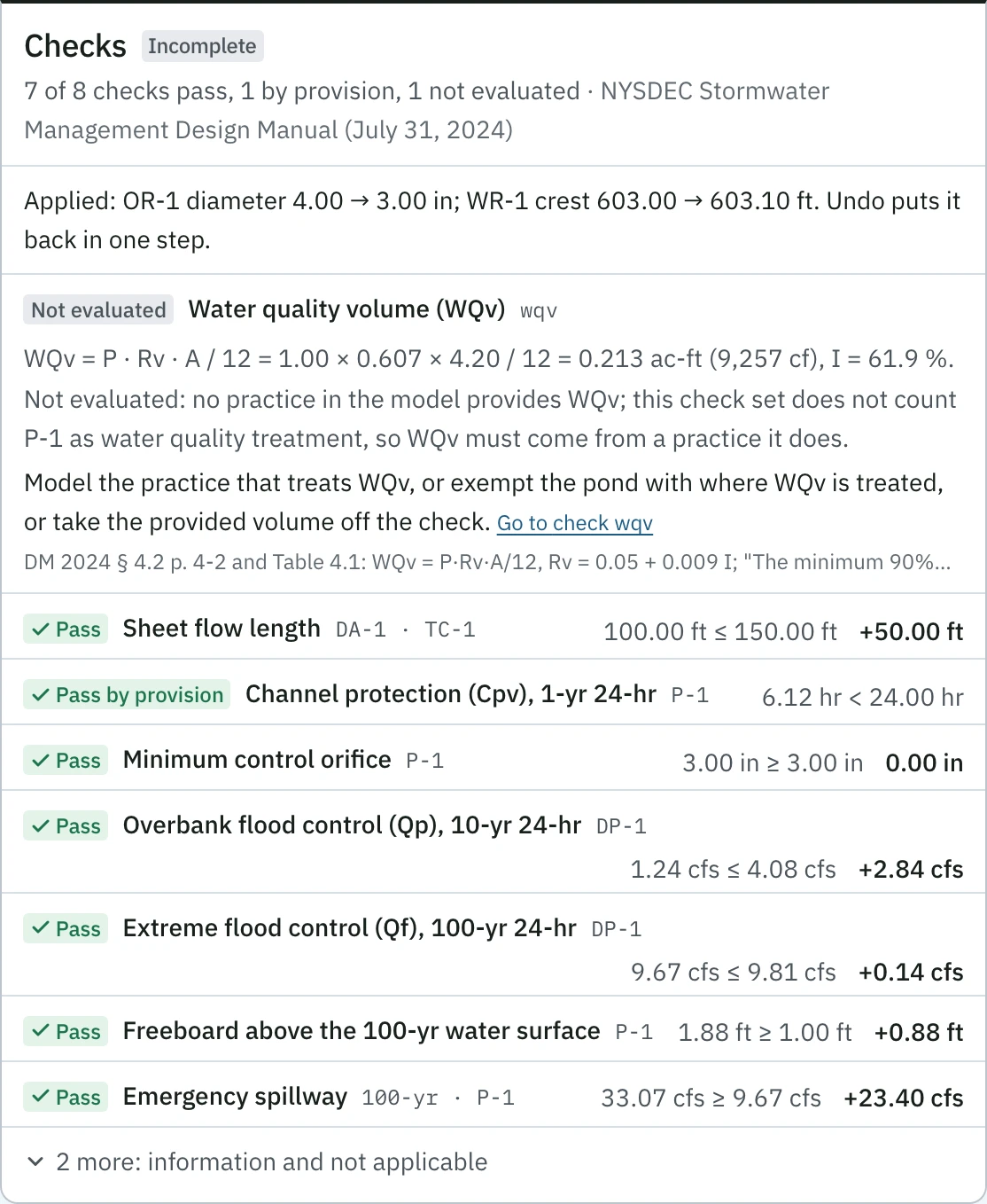
The Amherst retail pad's checks after the proposal is applied: Incomplete, 7 of 8 checks pass, 1 by provision, and 1 is not evaluated. A line says the change applied and that undo puts it back in one step. Cpv passes at 6.12 hr by provision; minimum orifice 3.00 in; Qp 1.24 cfs against 4.08 cfs; Qf 9.67 cfs against 9.81 cfs; freeboard 1.88 ft; emergency spillway 33.07 cfs. WQv stays not evaluated, with its hint on how to resolve it.
After Apply, Amherst retail pad: every outlet check passes; the run reads Incomplete, not Pass, until a practice in the model provides the WQv. Open at full size

The charts

Drawn by the engine from the run, the same on screen and in the PDF. Each has a table of its numbers beside it. These are the sample, the NYSDEC manual’s Chapter 8 example on the manual’s own inputs. Its routed 100-yr peak is 148.91 cfs, where the manual’s TR-20 routing prints 140.95 cfs (DM 2015 pp. 8-19 to 8-21). Two inputs to the routing differ. The manual’s 202 cfs inflow is from TR-55’s graphical method; PondSheet convolves the NRCS unit hydrograph to 222.78 cfs. The manual rates its earth spillway by a method it does not print; PondSheet counts the 3:1 side slopes (HEC-22 eq. 10.35).
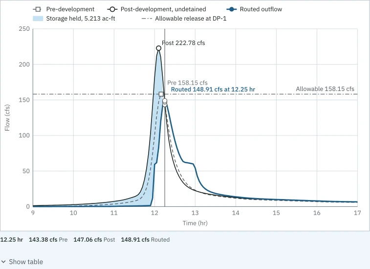
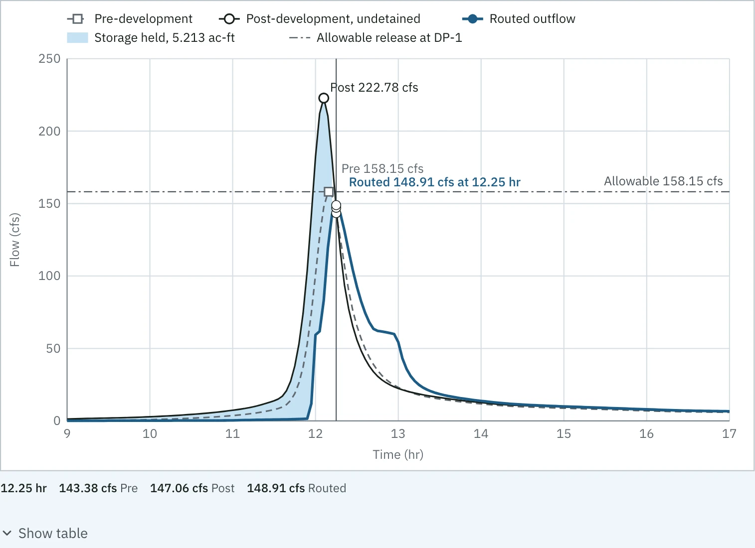
The 100-yr 24-hr hydrograph at design point DP-1 of the sample from 9 to 17 hr: pre-development dashed, post-development undetained peaking at 222.78 cfs, routed outflow peaking at 148.91 cfs at 12.25 hr, the storage held shaded at 5.213 ac-ft, and the allowable release line at 158.15 cfs. A crosshair at 12.25 hr reads 143.38 cfs pre, 147.06 cfs post and 148.91 cfs routed.
Hydrograph, the sample's 100-yr storm at DP-1: routed 148.91 cfs at 12.25 hr against an allowable 158.15 cfs. The crosshair reads every series at one time. Open at full size
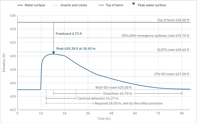
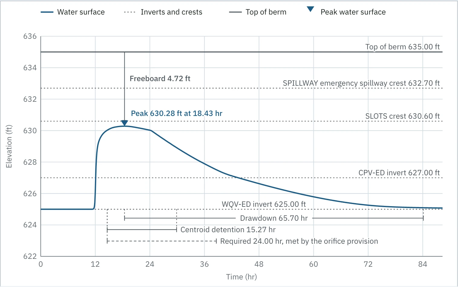
The 1-yr 24-hr water level in pond P-3 of the sample over 84 hours: it peaks at 630.28 ft at 18.43 hr, under the top of berm at 635.00 ft with freeboard 4.72 ft, against the outlet inverts and crests and the emergency spillway crest at 632.70 ft. Below, drawdown 65.70 hr, centroid detention 15.27 hr, and the required 24.00 hr drawn dashed, met by the orifice provision.
Water level, the sample's 1-yr storm in P-3: centroid detention 15.27 hr drawn against the required 24.00 hr, which passes on the 3 in orifice provision, with the drawdown and the freeboard. Open at full size
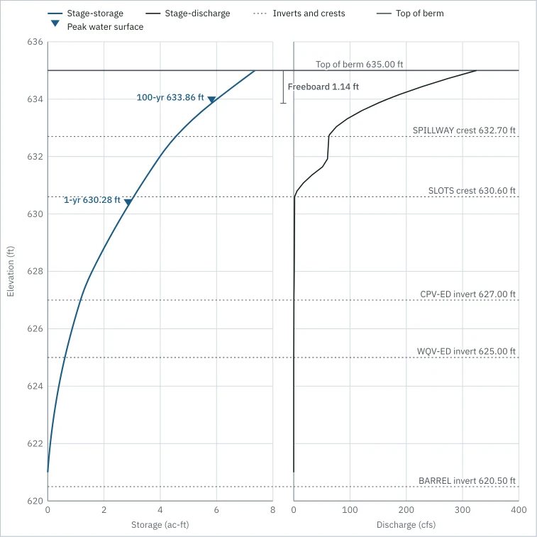
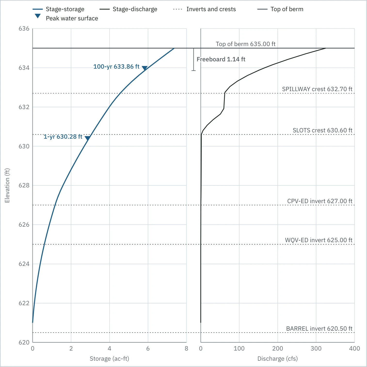
The stage-storage-discharge chart for pond P-3 of the sample: elevation from 620 to 636 ft against storage in ac-ft on the left and discharge in cfs on the right, with every outlet's invert and crest, the emergency spillway crest and the top of berm drawn across both, and each storm's peak water surface marked on the storage curve.
Stage-storage-discharge, the sample's pond P-3: storage and discharge on one elevation axis, with each storm's peak water surface marked. Open at full size
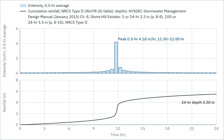
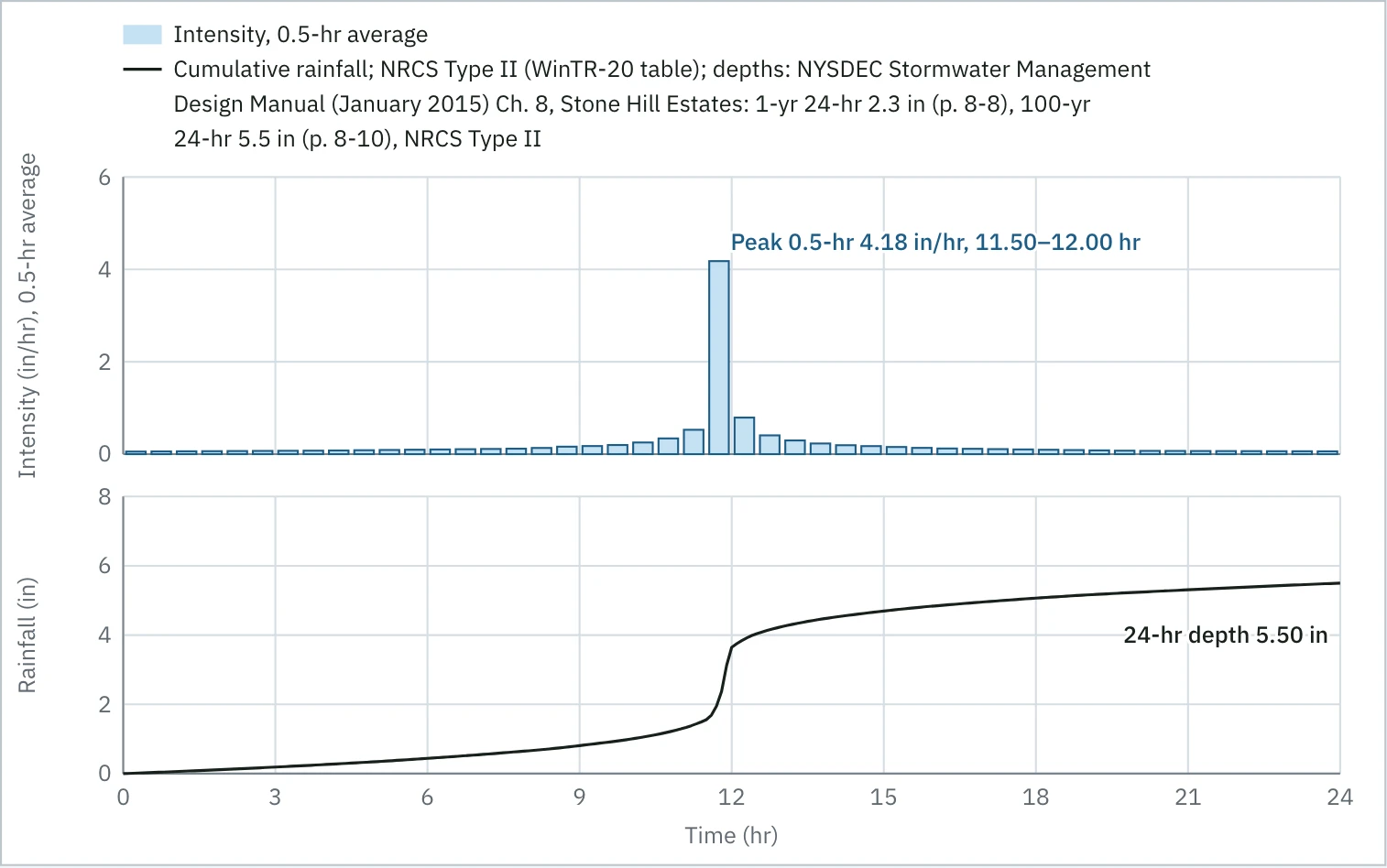
The sample's 100-yr 24-hr design storm, NRCS Type II from the WinTR-20 table on the depths the NYSDEC manual's Chapter 8 example prints: intensity in 0.5-hr bars over 24 hours, peaking at 4.18 in/hr from 11.50 to 12.00 hr, above the cumulative rainfall curve that reaches the 24-hr depth of 5.50 in.
Design storm, the sample's 100-yr Type II: 0.5-hr intensity bars peaking at 4.18 in/hr, over the cumulative depth to 5.50 in. Open at full size
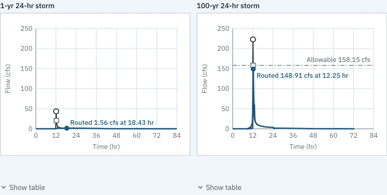
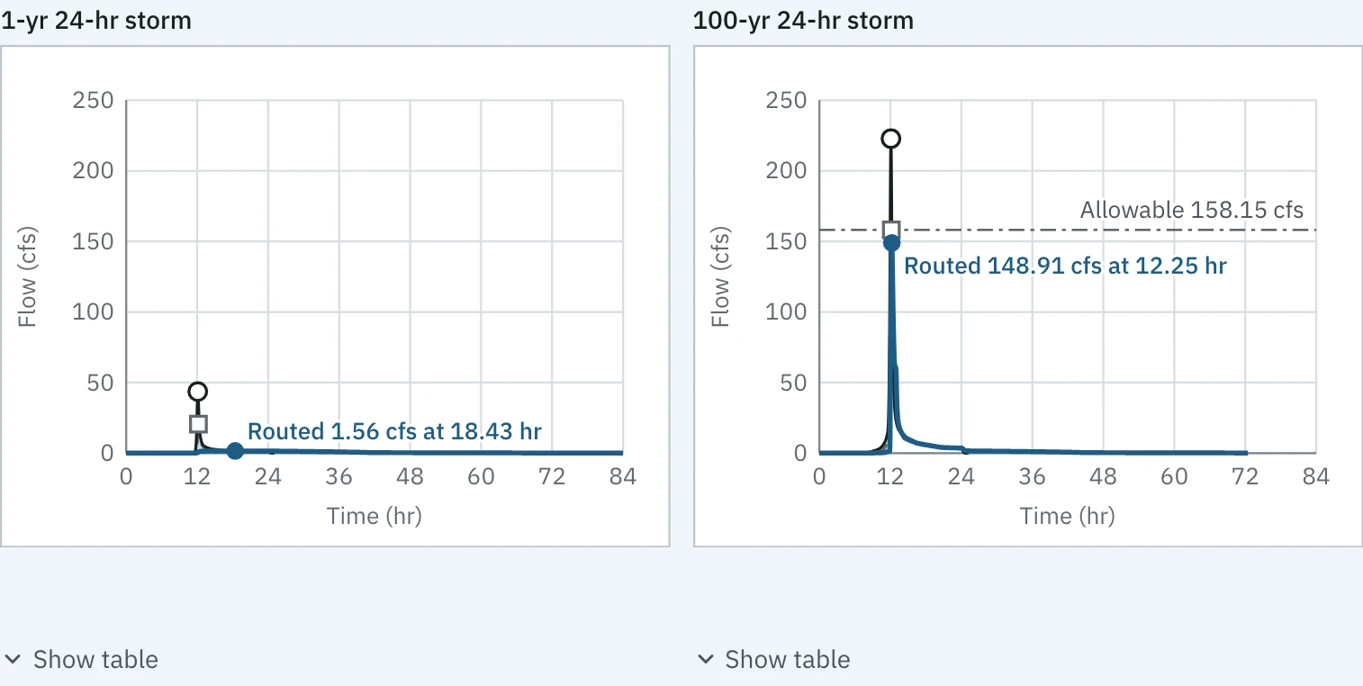
Compare storms on the sample: the 1-yr and the 100-yr hydrographs at DP-1 side by side on one pair of scales, 0 to 250 cfs and 0 to 84 hr. The 100-yr routed peak is labeled 148.91 cfs at 12.25 hr under its allowable 158.15 cfs; the 1-yr labels its routed 1.56 cfs at 18.43 hr, small on the same scale.
Compare storms, the sample at DP-1: the 1-yr and the 100-yr on one pair of scales, so the size of each response reads at a glance. Open at full size

One number, four places

The sample’s routed 100-yr peak at DP-1, 148.91 cfs, is the same number on the hydrograph above, in the workspace’s checks, in the report and on the reviewer’s page, because all four read the same stored run.
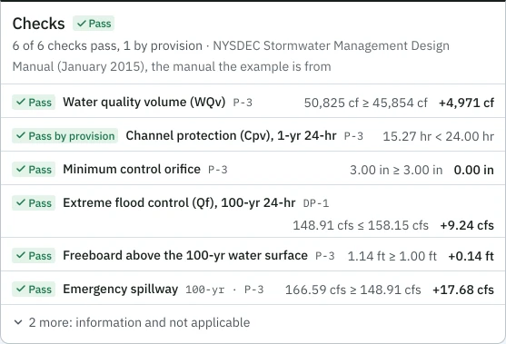
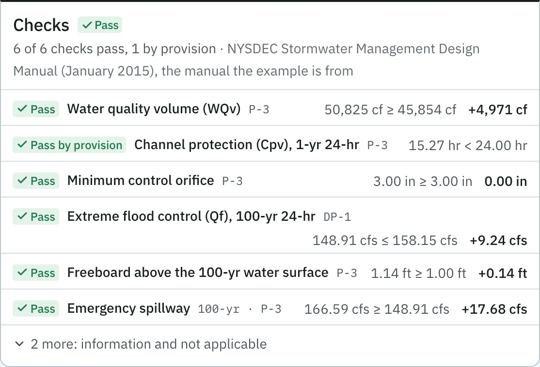
The sample's checks panel in the workspace: Pass, 6 of 6 checks pass, 1 by provision, against the NYSDEC 2015 manual. Extreme flood control (Qf), 100-yr 24-hr, at DP-1 reads 148.91 cfs ≤ 158.15 cfs with its margin; Cpv, tagged Pass by provision, reads 15.27 hr < 24.00 hr.
In the workspace: the sample's Qf check, 148.91 cfs ≤ 158.15 cfs at DP-1, with its margin. Open at full size
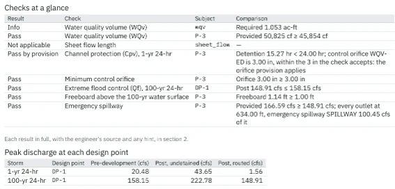
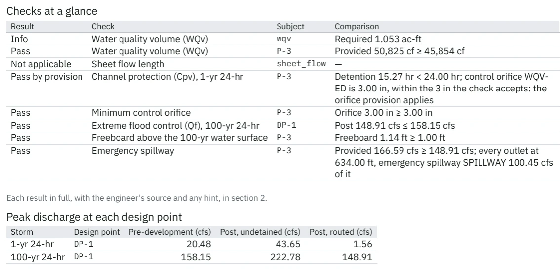
Page 2 of the sample's report: the Checks at a glance table, where Cpv reads Pass by provision and Qf at DP-1 reads Post 148.91 cfs ≤ 158.15 cfs, and the peak discharge table, where the 100-yr 24-hr storm at DP-1 has pre-development 158.15 cfs, post undetained 222.78 cfs and post routed 148.91 cfs.
In the report: the same 148.91 cfs on page 2 of the sample's PDF, in the checks and in the peak discharge table. Open at full size
The Qf entry on the sample's reviewer page: Pass, Extreme flood control (Qf), 100-yr 24-hr, DP-1, 148.91 cfs ≤ 158.15 cfs, then the sentence: post 100-yr peak 148.91 cfs against pre 158.15 cfs at DP-1, and the source cited.
On the reviewer’s page: the same 148.91 cfs, opened from the sample’s share link with no account. Open at full size

The report and the reviewer’s link

In: the saved run. Out: a PDF with every input and check, a SWMM 5 .inp per storm, the model file, and a read-only link the reviewer opens with no account.
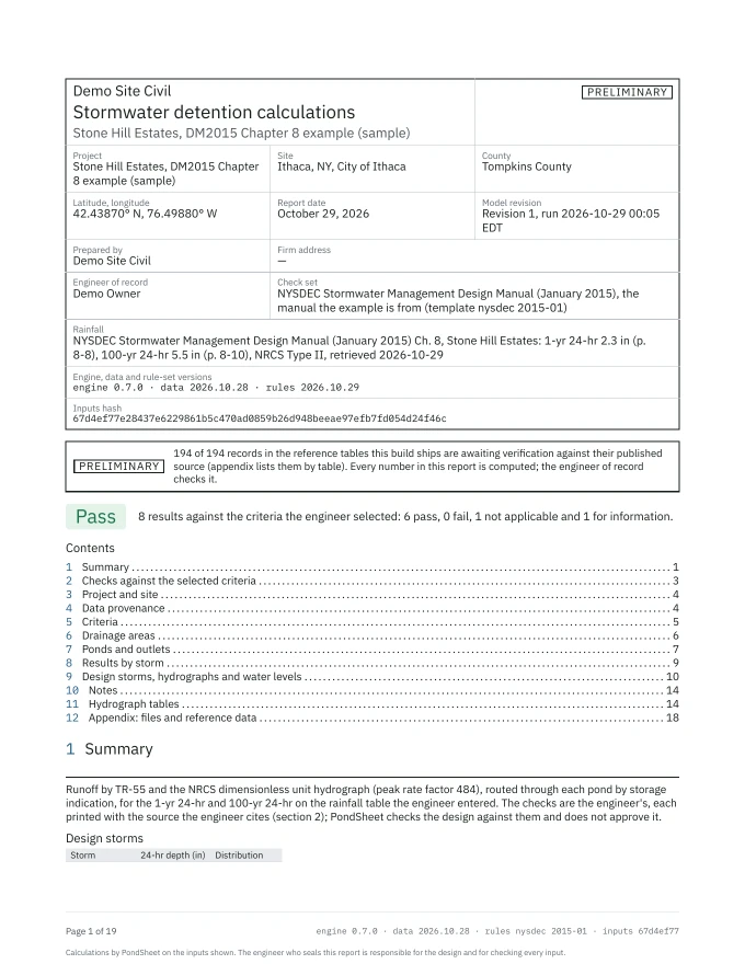
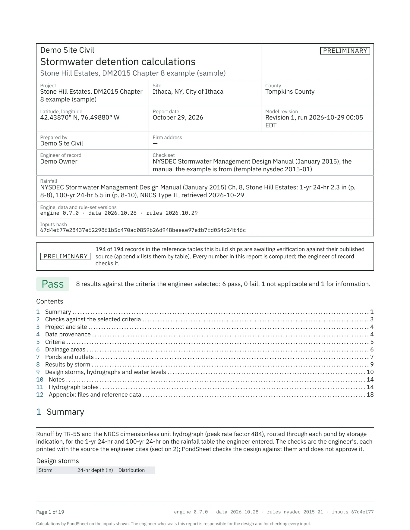
Page 1 of a PondSheet report for the Stone Hill Estates sample. A title block gives the project, the site (Ithaca, NY, City of Ithaca) and its county, latitude and longitude, who prepared it, the report date, the model revision, the check set (the NYSDEC design manual, January 2015), the rainfall with its source pages and retrieval date, the engine, data and rule-set versions and the inputs hash. Under it a PRELIMINARY notice, a Pass verdict with 8 results against the criteria the engineer selected (6 pass, 1 not applicable, 1 for information), a contents list of twelve sections and the start of the summary with the two design storms.
Page 1 of the PDF the server generated for the sample project, the NYSDEC manual’s own Chapter 8 example. PRELIMINARY because the reference tables are still being checked against their printed sources. Open at full size
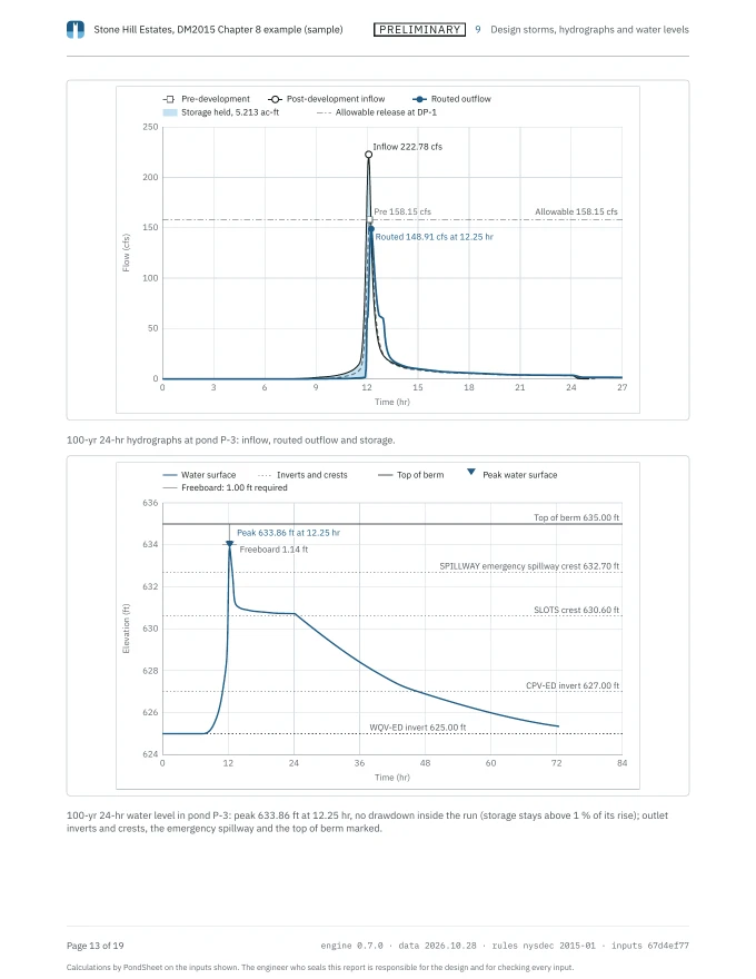
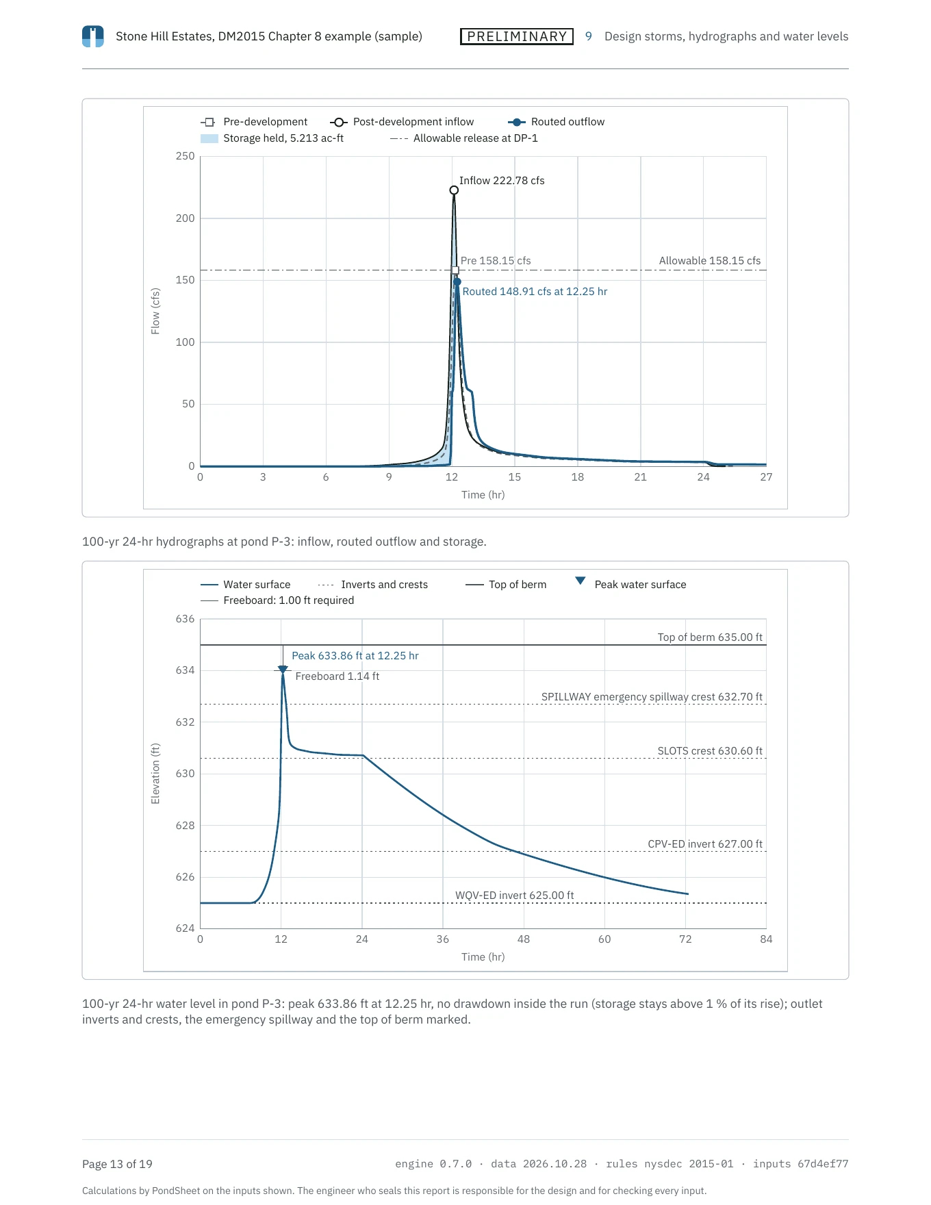
Page 13 of the same report. Above, the 100-yr 24-hr hydrographs at pond P-3: post-development inflow peaking at 222.78 cfs, the pre-development peak and allowable release at 158.15 cfs, and the routed outflow peaking at 148.91 cfs at 12.25 hr, with the storage held shaded. Below, the pond’s water level over 84 hours against its outlet inverts and crests, the emergency spillway crest at 632.70 ft and the top of berm at 635.00 ft, peaking at 633.86 ft at 12.25 hr with 1.14 ft of freeboard, the key naming the 1.00 ft of freeboard required.
The same report’s 100-yr page for the sample: the routed hydrograph, then the pond’s water level against every outlet and the top of berm, drawn from the engine’s run like every chart in the app. Open at full size
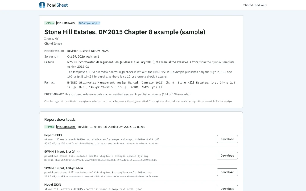
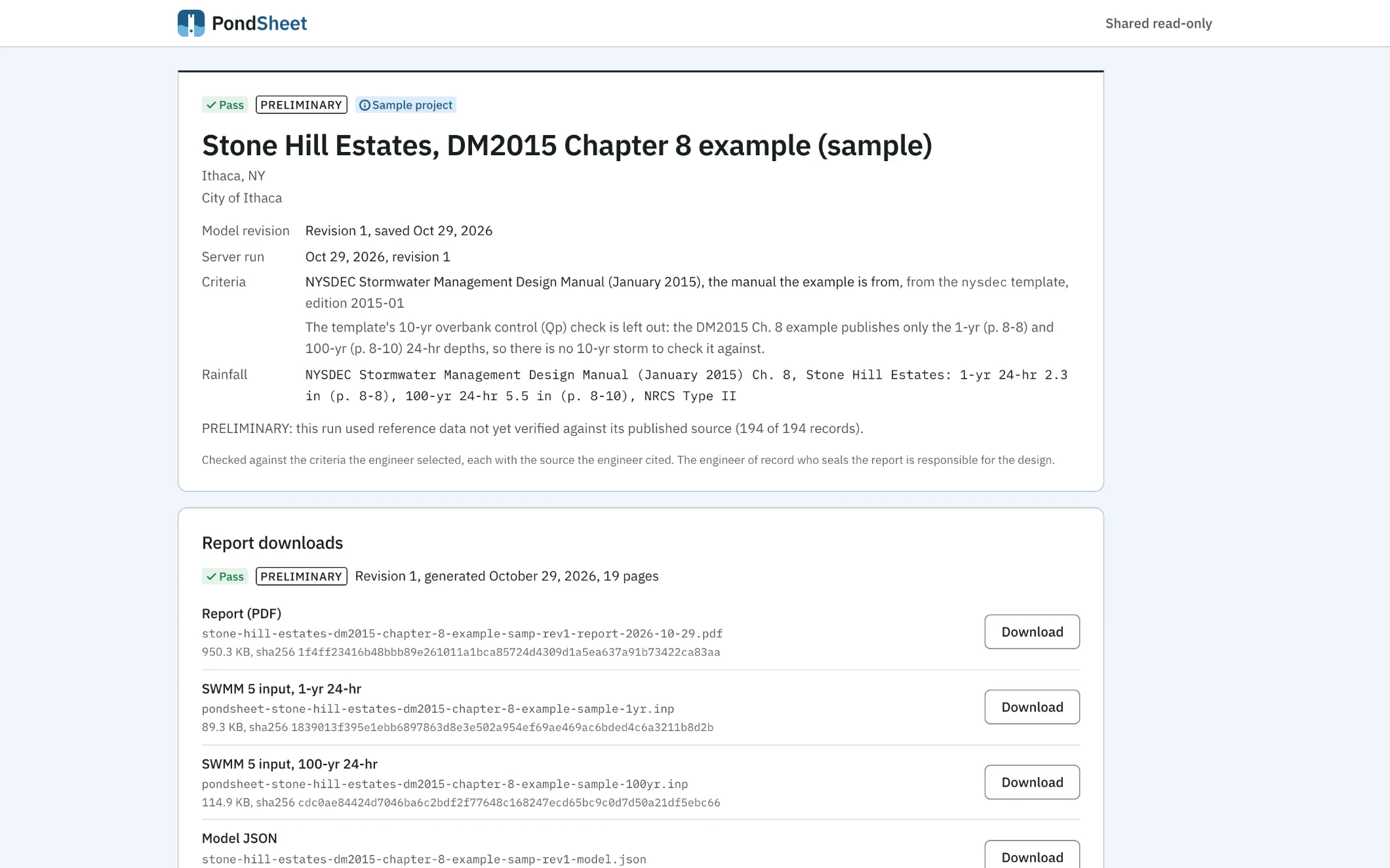
The read-only page a plan reviewer opens from a share link, with only the PondSheet lockup and “Shared read-only” across the top. A title block carries Pass, PRELIMINARY and Sample project tags, the project name, the City of Ithaca, the model revision and server run, the criteria with the engineer’s note on why the 10-yr check is left out, and the rainfall source. Below it, report downloads: the 19-page PDF, a SWMM 5 input for the 1-yr and the 100-yr storm and the model JSON, each with its file name, size and SHA-256.
What a reviewer sees from the sample’s share link, with no account: the title block, the criteria and rainfall source, and the PDF, SWMM files and model, each with its checksum. Open at full size

Run your own site the same way. How the numbers are checked

14-day trial, every feature, no card.